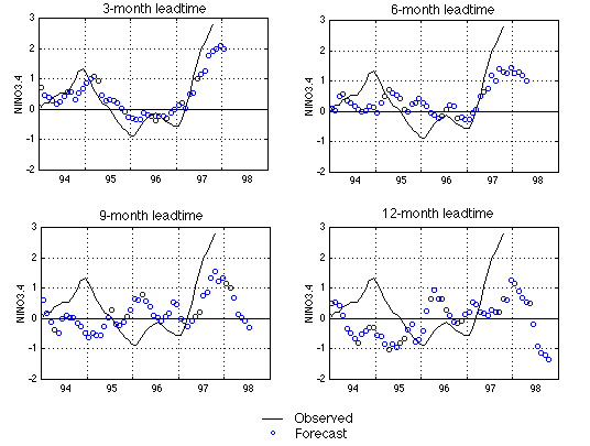
The average tropical Pacific sea surface temperature anomaly (SSTA) in the NINO3.4 region (5N-5S, 170W-120W) is often used as an El Nino index.
The figure shows our latest forecast using a neural network model trained with data up to October 1997. The four panels are for 3-, 6-, 9-month and 12-month leadtimes respectively. The black line is the observed SSTA (in degree Celsius), and the blue circles are forecasts.
Models of all 4 leadtimes indicate an increase of NINO3.4 in the coming months, forming a full scale El Nino event by the end 1997. The NINO3.4 returns to normal by the mid-1998, as the forecasts of 9- and 12-month leadtimes indicate.
In previous forecasts, wind stress data of the tropical Pacific Ocean were used as predictor. In this month, we have changed the predictor to the sea level pressure (SLP) data of the tropical Pacific Ocean. We found that the SLP data give better skill for leadtimes longer than 6 months.