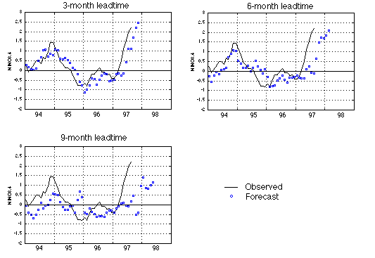
The average tropical Pacific sea surface temperature anomaly (SSTA) in the NINO3.4 region (5N-5S, 170W-120W) is often used as an El Nino index.
The figure shows our latest forecast using a neural network model trained with data up to August 1997. The three panels are for 3-, 6-, and 9-month leadtimes respectively. The black line is the observed SSTA (in degree Celsius), and the blue circles are forecasts.
Models of all 3 leadtimes indicate an increase of NINO3.4 in the coming months, possibly forming a full scale El Nino event in 1997. The wind data from April 1997 on carry a strong warm-event precursor signal.
Note: In forecasts issued before, we were using the old NINO3.4 index from NCEP. From this month on, we have changed to the new NINO3.4 index found in NCEP/NOAA. Click here to see a note from NCEP/NOAA on the change in calculating NINO3.4.
We will also be making forecasts for the SSTA field of the entire Pacific, and possibly for the global domain, which can be used to drive atmosphere general circulation models to produce seasonal forecasts.