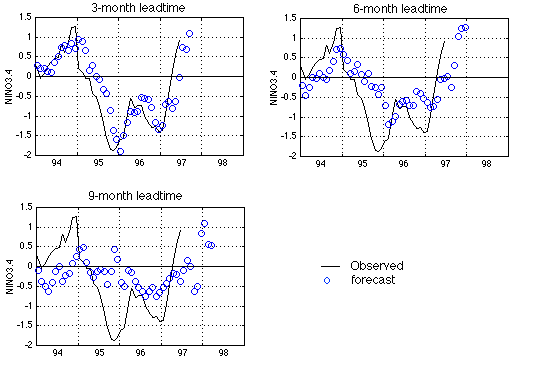
The average tropical Pacific sea surface temperature anomaly (SSTA) in the NINO3.4 region (5N-5S, 170W-120W) is often used as an El Nino index.
The figure shows our latest forecast using a neural network model trained with data up to June 1997. The three panels are for 3-, 6-, and 9-month leadtimes respectively. The black line is the observed SSTA (in degree Celsius), and the blue circles are forecasts.
Models of all 3 leadtimes indicate an increase of NINO3.4 in the coming months, possibly forming a full scale El Nino event in 1997. The wind data of April, May and June of 1997 carries a strong warm-event precursor signal.
Western Canada tends to be warmer and slightly drier during an El Nino winter. The coastal waters off western Canada also tend to be warmer during an El Nino, together with a northward diversion of the return migration path of the Fraser River sockeye salmon.
Click here for more detail about our model.
We will also be making forecasts for the SSTA field of the entire Pacific, and possibly for the global domain, which can be used to drive atmosphere general circulation models to produce seasonal forecasts.